How To Read A Surface Analysis Chart
Ronan Farrow
Apr 02, 2025 · 3 min read

Table of Contents
How to Read a Surface Analysis Chart: A Comprehensive Guide
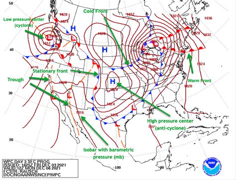
Surface analysis charts, also known as surface weather maps, are crucial tools for meteorologists and weather enthusiasts alike. They provide a snapshot of atmospheric conditions across a specific geographical area at a given time. Understanding how to interpret these charts is key to predicting weather patterns and understanding current conditions. This guide will break down the essential elements and provide you with the skills to confidently read a surface analysis chart.
Understanding the Basics: Key Elements of a Surface Analysis Chart
A typical surface analysis chart is packed with information, but it's not as daunting as it might first appear. Let's focus on the key components:
1. Isobars: Lines of Equal Pressure
Isobars are the most prominent features. These lines connect points of equal atmospheric pressure, typically measured in millibars (mb) or hectopascals (hPa). Closely spaced isobars indicate a steep pressure gradient, signifying strong winds. Widely spaced isobars suggest a weak pressure gradient and lighter winds.
2. Highs and Lows: Pressure Systems
High-pressure systems (anticyclones) are areas of relatively high atmospheric pressure, often associated with fair weather and calm conditions. They are depicted as 'H' on the chart. Conversely, low-pressure systems (cyclones) represent areas of relatively low pressure, usually associated with stormy or unsettled weather. These are denoted by 'L'.
3. Fronts: Boundaries Between Air Masses
Fronts are boundaries separating air masses with different temperatures and humidity. Understanding fronts is crucial for predicting weather changes:
- Cold Fronts: Represented by a line with triangles pointing in the direction of movement. Cold fronts bring rapid changes in temperature and often result in thunderstorms and gusty winds.
- Warm Fronts: Shown as a line with semicircles pointing in the direction of movement. Warm fronts typically bring gradual warming and often precede precipitation.
- Occluded Fronts: A combination of cold and warm fronts, represented by a purple line with alternating triangles and semicircles. These often bring widespread precipitation and complex weather patterns.
- Stationary Fronts: These fronts show little to no movement and are represented by alternating triangles and semicircles pointing in opposite directions. They can bring prolonged periods of precipitation.
4. Weather Symbols: A Quick Look at Current Conditions
Surface analysis charts include various symbols representing current weather conditions at specific locations. These symbols usually denote things like:
- Precipitation: Rain, snow, sleet, etc.
- Cloud cover: Clear skies, partly cloudy, overcast, etc.
- Visibility: Fog, haze, etc.
5. Temperature and Dew Point: Understanding Humidity
Many charts will also include temperature and dew point readings at various locations. The difference between these two values gives you an indication of the relative humidity. A smaller difference indicates higher humidity and a greater potential for precipitation.
Interpreting the Chart: Putting it All Together
To effectively interpret a surface analysis chart, consider the following steps:
- Identify the highs and lows: Locate the 'H' and 'L' symbols. These are the dominant features influencing the weather.
- Analyze the isobars: Note the spacing of the isobars to understand wind speed and direction. Closely spaced isobars generally signify stronger winds.
- Examine the fronts: Identify the types of fronts and their movement. This will give you a strong indication of impending weather changes.
- Observe the weather symbols: Use these symbols to understand the current weather conditions across the region.
- Consider the temperature and dew point data: This provides insight into the humidity levels and precipitation potential.
By systematically analyzing these elements, you can gain a much better understanding of current and future weather patterns.
Advanced Techniques and Resources
For more advanced analysis, you can explore resources such as online meteorology courses or specialized weather software. Practice is key; the more surface analysis charts you examine, the more comfortable and proficient you'll become.
This comprehensive guide provides a solid foundation for understanding and interpreting surface analysis charts. With practice and consistent learning, you'll be able to effectively utilize these charts to understand and predict weather conditions. Remember to consult multiple sources and constantly refine your skills to become a more confident weather interpreter.
Featured Posts
Also read the following articles
| Article Title | Date |
|---|---|
| How To Ride A Bike In A Dress | Apr 02, 2025 |
| How To Transport Beehives | Apr 02, 2025 |
| How To Sanitize Rv Fresh Water Tank With Bleach | Apr 02, 2025 |
| How To Report Tenant For Non Payment Of Rent | Apr 02, 2025 |
| How To Tune 1 9 Tdi | Apr 02, 2025 |
Latest Posts
-
How He Loves Us Sheet Music
Apr 04, 2025
-
How He Loves Music Sheet
Apr 04, 2025
-
How Has Softball Changed Over The Years
Apr 04, 2025
-
How Hard Is The Real Estate Exam In California
Apr 04, 2025
-
How Hard Is The Lsat Compared To The Mcat
Apr 04, 2025
Thank you for visiting our website which covers about How To Read A Surface Analysis Chart . We hope the information provided has been useful to you. Feel free to contact us if you have any questions or need further assistance. See you next time and don't miss to bookmark.
